Rhoose night lights from space
Night Light of Rhoose (Wales) from space (United Kingdom) Src. Average luminocity for 10x10km area is 11.8165% and for 50x50km: 13.0352%.
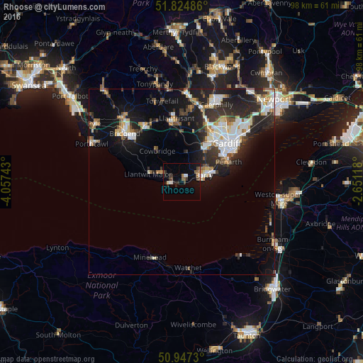
Analysis of Rhoose night lights 2016
Square area 10x10 km:
 1.26%
1.26%90-99
1.4%80-89
0.42%70-79
0.28%60-69
1.82%50-59
2.66%40-49
1.68%30-39
2.1%20-29
4.06%10-19
7.42%0-9
76.89%Square area 50x50 km:
2.46%90-99
2.83%80-89
1.05%70-79
1.28%60-69
1.2%50-59
0.97%40-49
1.46%30-39
2.02%20-29
4.89%10-19
8.5%0-9
73.33%Clear (daylight) street map image can be seen on geolist.org.
Map coordinates:
51° 49' 29.5" North, 4° 3' 26.7" West
51° 23' 17.4" North, 3° 21' 15.5" West
50° 56' 50.3" North, 2° 39' 4.2" West
Some cities around Rhoose sort by population:
• Cardiff
15.8 km =9.8 mi,  49°
49°
• Barry
5.1 km =3.2 mi,  75°
75°
• Penarth
13.7 km =8.5 mi,  65°
65°
• Llantrisant
17 km =10.6 mi,  355°
355°
• Llantwit Major
9.5 km =5.9 mi,  285°
285°
• Dinas Powys
11 km =6.8 mi,  61°
61°
• Pontyclun
15.1 km =9.4 mi,  350°
350°
• Llanharan
17.7 km =11 mi,  340°
340°
2639444 (p: 6,160)
Sources (retrieved 2019-11-25):
» Earth at Night: Flat Maps 2012, 2016