Llantwit Major night lights from space
Night Light of Llantwit Major (Wales) from space (United Kingdom) Src. Average luminocity for 10x10km area is 4.4272% and for 50x50km: 12.3763%.
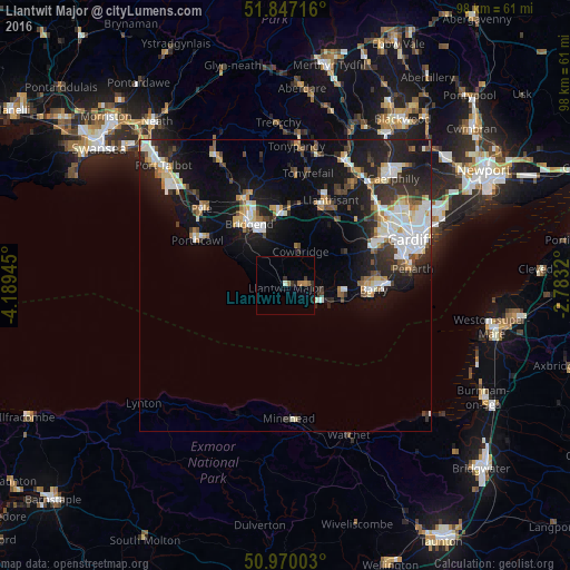
Analysis of Llantwit Major night lights 2016
Square area 10x10 km:
 0%
0%90-99
0.56%80-89
0%70-79
0.56%60-69
1.96%50-59
0.28%40-49
0%30-39
1.4%20-29
1.26%10-19
1.26%0-9
92.72%Square area 50x50 km:
2.18%90-99
2.55%80-89
1.06%70-79
1.22%60-69
1.19%50-59
1.14%40-49
1.4%30-39
1.91%20-29
4.11%10-19
9.61%0-9
73.63%Clear (daylight) street map image can be seen on geolist.org.
Map coordinates:
51° 50' 49.8" North, 4° 11' 22" West
51° 24' 38.5" North, 3° 29' 10.8" West
50° 58' 12.1" North, 2° 46' 59.5" West
Some cities around Llantwit Major sort by population:
• Bridgend
12.3 km =7.6 mi,  329°
329°
• Barry
14.1 km =8.8 mi,  94°
94°
• Coity
13.3 km =8.3 mi,  338°
338°
• Pencoed
12.6 km =7.8 mi,  355°
355°
• Brynna
14.3 km =8.9 mi,  6°
6°
• Rhoose
9.5 km =5.9 mi,  105°
105°
• Pontyclun
14 km =8.7 mi,  28°
28°
• Llanharan
14.5 km =9 mi, 13°
2643933 (p: 14,384)
Sources (retrieved 2019-11-25):
» Earth at Night: Flat Maps 2012, 2016