Princes Risborough night lights from space
Night Light of Princes Risborough (England) from space (United Kingdom) Src. Average luminocity for 10x10km area is 3.8193% and for 50x50km: 14.3007%.
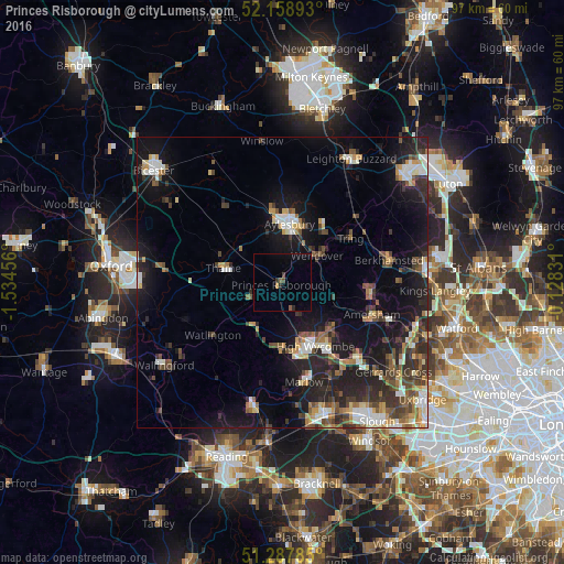
Analysis of Princes Risborough night lights 2016
Square area 10x10 km:
 0%
0%90-99
0%80-89
0%70-79
0.56%60-69
0%50-59
1.12%40-49
0.98%30-39
0.7%20-29
1.12%10-19
0.14%0-9
95.38%Square area 50x50 km:
1.73%90-99
2.18%80-89
1.32%70-79
1.45%60-69
1.69%50-59
1.87%40-49
2.64%30-39
2.72%20-29
4.81%10-19
11.67%0-9
67.93%Clear (daylight) street map image can be seen on geolist.org.
Map coordinates:
52° 9' 32.1" North, 1° 32' 4.4" West
51° 43' 31.8" North, 0° 49' 53.2" West
51° 17' 16.3" North, 0° 7' 41.9" West
Some cities around Princes Risborough sort by population:
• High Wycombe
12.1 km =7.5 mi,  152°
152°
• Aylesbury
10.2 km =6.3 mi,  6°
6°
• Chesham
16.2 km =10.1 mi,  100°
100°
• Tring
14.2 km =8.8 mi,  57°
57°
• Thame
10.3 km =6.4 mi,  284°
284°
• Wendover
7.5 km =4.7 mi, 57°
• Great Missenden
8.8 km =5.5 mi,  105°
105°
• Chinnor
6.1 km =3.8 mi,  244°
244°
2639888 (p: 8,231)
Sources (retrieved 2019-11-25):
» Earth at Night: Flat Maps 2012, 2016