Tonyrefail night lights from space
Night Light of Tonyrefail (Wales) from space (United Kingdom) Src. Average luminocity for 10x10km area is 13.3142% and for 50x50km: 17.5164%.
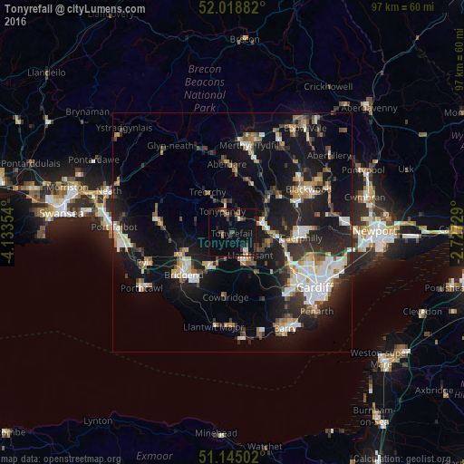
Analysis of Tonyrefail night lights 2016
Square area 10x10 km:
 0.67%
0.67%90-99
0.8%80-89
0.13%70-79
0.8%60-69
2.27%50-59
2.54%40-49
2.14%30-39
4.55%20-29
2.01%10-19
10.83%0-9
73.26%Square area 50x50 km:
2.51%90-99
3.11%80-89
1.43%70-79
1.91%60-69
1.97%50-59
1.91%40-49
2.22%30-39
2.77%20-29
5.83%10-19
16.17%0-9
60.17%Clear (daylight) street map image can be seen on geolist.org.
Map coordinates:
52° 1' 7.8" North, 4° 8' 0.7" West
51° 35' 2.5" North, 3° 25' 49.5" West
51° 8' 42.1" North, 2° 43' 38.2" West
Some cities around Tonyrefail sort by population:
• Tonypandy
4.6 km =2.9 mi,  337°
337°
• Pontypridd
6.4 km =4 mi,  71°
71°
• Llantrisant
6.2 km =3.9 mi,  141°
141°
• Pencoed
8.3 km =5.2 mi,  215°
215°
• Beddau
6 km =3.7 mi,  123°
123°
• Brynna
5.6 km =3.5 mi,  204°
204°
• Pontyclun
7.4 km =4.6 mi,  158°
158°
• Llanharan
5.1 km =3.2 mi,  186°
186°
2635689 (p: 9,317)
Sources (retrieved 2019-11-25):
» Earth at Night: Flat Maps 2012, 2016