Paddock Wood night lights from space
Night Light of Paddock Wood (England) from space (United Kingdom) Src. Average luminocity for 10x10km area is 5.381% and for 50x50km: 11.9981%.
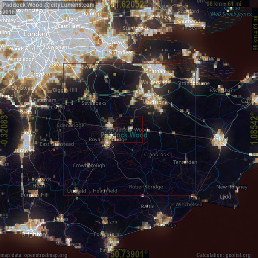
Analysis of Paddock Wood night lights 2016
Square area 10x10 km:
 0.27%
0.27%90-99
0.27%80-89
0%70-79
0.53%60-69
0.67%50-59
0.94%40-49
1.6%30-39
1.47%20-29
1.2%10-19
0.8%0-9
92.25%Square area 50x50 km:
1.17%90-99
1.97%80-89
1.24%70-79
1.62%60-69
1.89%50-59
1.59%40-49
1.6%30-39
2.66%20-29
3.8%10-19
8.18%0-9
74.27%Clear (daylight) street map image can be seen on geolist.org.
Map coordinates:
51° 37' 13.9" North, 0° 19' 15" West
51° 10' 54.7" North, 0° 22' 56.2" East
50° 44' 20.4" North, 1° 5' 7.5" East
Some cities around Paddock Wood sort by population:
• Maidstone
13.3 km =8.3 mi,  44°
44°
• Royal Tunbridge Wells
9.9 km =6.2 mi,  237°
237°
• Tonbridge
7.7 km =4.8 mi,  281°
281°
• Sevenoaks
16.8 km =10.4 mi,  306°
306°
• Snodland
17 km =10.6 mi,  14°
14°
• Larkfield
14.1 km =8.8 mi,  19°
19°
• Pembury
6 km =3.7 mi,  224°
224°
• Staplehurst
12.1 km =7.5 mi,  101°
101°
2640690 (p: 7,840)
Sources (retrieved 2019-11-25):
» Earth at Night: Flat Maps 2012, 2016