Yarm night lights from space
Night Light of Yarm (England) from space (United Kingdom) Src. Average luminocity for 10x10km area is 28.7129% and for 50x50km: 16.3746%.
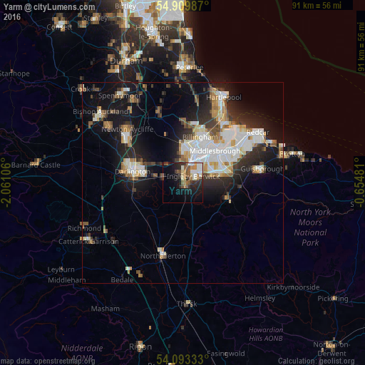
Analysis of Yarm night lights 2016
Square area 10x10 km:
 4.43%
4.43%90-99
6.58%80-89
2.39%70-79
1.44%60-69
4.67%50-59
6.34%40-49
2.39%30-39
3.71%20-29
8.49%10-19
18.06%0-9
41.51%Square area 50x50 km:
3.29%90-99
3.87%80-89
1.39%70-79
1.45%60-69
1.9%50-59
1.75%40-49
1.53%30-39
2.44%20-29
4.14%10-19
10.69%0-9
67.55%Clear (daylight) street map image can be seen on geolist.org.
Map coordinates:
54° 54' 35.5" North, 2° 3' 39.8" West
54° 30' 13.1" North, 1° 21' 28.5" West
54° 5' 36" North, 0° 39' 17.3" West
Some cities around Yarm sort by population:
• Middlesbrough
11.3 km =7 mi,  44°
44°
• Darlington
12.6 km =7.8 mi,  280°
280°
• Stockton-on-Tees
7.6 km =4.7 mi,  19°
19°
• Billingham
10.4 km =6.5 mi, 24°
• Newton Aycliffe
18.8 km =11.7 mi,  312°
312°
• Thornaby-on-Tees
5 km =3.1 mi,  48°
48°
• Ingleby Greenhow
17.3 km =10.7 mi,  110°
110°
• Eaglescliffe
2.4 km =1.5 mi,  11°
11°
2633415 (p: 19,184)
Sources (retrieved 2019-11-25):
» Earth at Night: Flat Maps 2012, 2016