Richmond night lights from space
Night Light of Richmond (England) from space (United Kingdom) Src. Average luminocity for 10x10km area is 7.0778% and for 50x50km: 3.9209%.
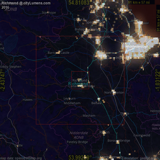
Analysis of Richmond night lights 2016
Square area 10x10 km:
 0.36%
0.36%90-99
0.96%80-89
0.6%70-79
0.84%60-69
1.56%50-59
2.75%40-49
0.6%30-39
1.08%20-29
1.08%10-19
0.84%0-9
89.35%Square area 50x50 km:
0.32%90-99
0.63%80-89
0.35%70-79
0.49%60-69
0.63%50-59
0.61%40-49
0.46%30-39
0.5%20-29
1.09%10-19
3.59%0-9
91.31%Clear (daylight) street map image can be seen on geolist.org.
Map coordinates:
54° 48' 39" North, 2° 26' 14.9" West
54° 24' 13" North, 1° 44' 3.6" West
53° 59' 32.2" North, 1° 1' 52.4" West
Some cities around Richmond sort by population:
• Darlington
17.9 km =11.1 mi,  41°
41°
• Bishop Auckland
28.3 km =17.6 mi,  7°
7°
• Newton Aycliffe
26.1 km =16.2 mi,  23°
23°
• Yarm
26.8 km =16.7 mi,  65°
65°
• Northallerton
20.8 km =12.9 mi,  110°
110°
• Catterick Garrison
3 km =1.9 mi,  165°
165°
• Shildon
25.9 km =16.1 mi, 13°
• Barnard Castle
19.4 km =12.1 mi,  322°
322°
2639388 (p: 8,413)
Sources (retrieved 2019-11-25):
» Earth at Night: Flat Maps 2012, 2016