Mold night lights from space
Night Light of Mold (Wales) from space (United Kingdom) Src. Average luminocity for 10x10km area is 17.2311% and for 50x50km: 16.8222%.
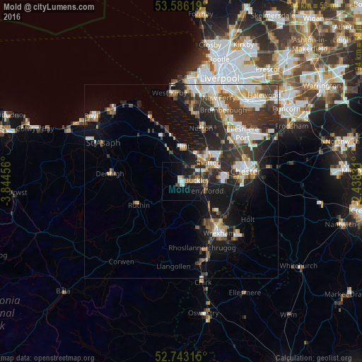
Analysis of Mold night lights 2016
Square area 10x10 km:
100  2.02%
2.02%
90-99 3.16%
80-89 0.88%
70-79 0%
60-69 4.04%
50-59 2.78%
40-49 1.89%
30-39 2.9%
20-29 4.04%
10-19 19.82%
0-9 58.46%
2.02%90-99
3.16%80-89
0.88%70-79
0%60-69
4.04%50-59
2.78%40-49
1.89%30-39
2.9%20-29
4.04%10-19
19.82%0-9
58.46%Square area 50x50 km:
100 3.32%
90-99 3.4%
80-89 1.45%
70-79 1.39%
60-69 1.63%
50-59 1.76%
40-49 2.63%
30-39 3.83%
20-29 5.47%
10-19 9.11%
0-9 66.01%
3.32%90-99
3.4%80-89
1.45%70-79
1.39%60-69
1.63%50-59
1.76%40-49
2.63%30-39
3.83%20-29
5.47%10-19
9.11%0-9
66.01%Clear (daylight) street map image can be seen on geolist.org.
Map coordinates:
53° 35' 10.3" North, 3° 50' 40.4" West
53° 10' 0.3" North, 3° 8' 29.1" West
52° 44' 35.3" North, 2° 26' 17.9" West
Some cities around Mold sort by population:
• Buckley
3.9 km =2.4 mi,  90°
90°
• Deeside
7.8 km =4.8 mi,  61°
61°
• Flint
8.7 km =5.4 mi,  3°
3°
• Hawarden
8 km =5 mi,  75°
75°
• Brymbo
12.2 km =7.6 mi,  155°
155°
• Holywell
13.3 km =8.3 mi,  334°
334°
• Broughton
9.9 km =6.2 mi, 92°
• Ruthin
13.2 km =8.2 mi,  243°
243°
2642372 (p: 10,058)
Sources (retrieved 2019-11-25):
» Earth at Night: Flat Maps 2012, 2016