Brymbo night lights from space
Night Light of Brymbo (Wales) from space (United Kingdom) Src. Average luminocity for 10x10km area is 19.8188% and for 50x50km: 9.7922%.
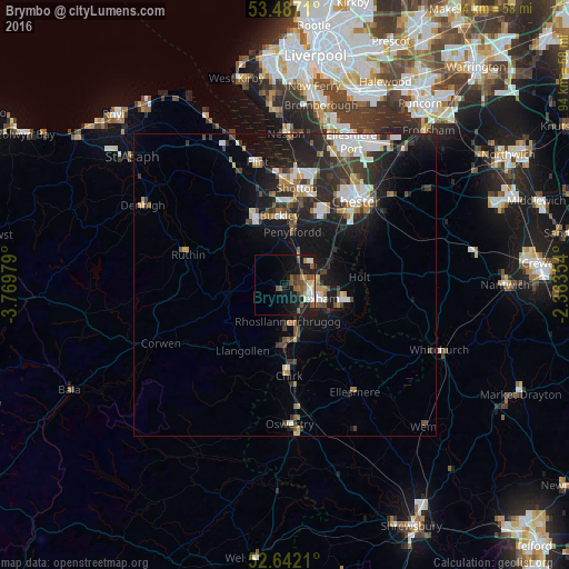
Analysis of Brymbo night lights 2016
Square area 10x10 km:
 2.65%
2.65%90-99
2.65%80-89
2.12%70-79
1.85%60-69
1.06%50-59
6.88%40-49
3.57%30-39
1.98%20-29
4.63%10-19
18.12%0-9
54.5%Square area 50x50 km:
1.69%90-99
1.71%80-89
0.7%70-79
0.81%60-69
1.11%50-59
1.12%40-49
1.32%30-39
1.98%20-29
3.74%10-19
7.77%0-9
78.06%Clear (daylight) street map image can be seen on geolist.org.
Map coordinates:
53° 29' 13.6" North, 3° 46' 11.2" West
53° 4' 0" North, 3° 4' 0" West
52° 38' 31.6" North, 2° 21' 48.7" West
Some cities around Brymbo sort by population:
• Wrexham
5.5 km =3.4 mi,  113°
113°
• Buckley
11.2 km =7 mi,  354°
354°
• Hawarden
13.4 km =8.3 mi,  11°
11°
• Rhosllanerchrugog
6.4 km =4 mi,  174°
174°
• Mold
12.2 km =7.6 mi,  335°
335°
• Broughton
11.8 km =7.3 mi,  24°
24°
• Coedpoeth
1.4 km =0.9 mi, 168°
• Gresford
6.7 km =4.2 mi,  72°
72°
2654450 (p: 18,111)
Sources (retrieved 2019-11-25):
» Earth at Night: Flat Maps 2012, 2016