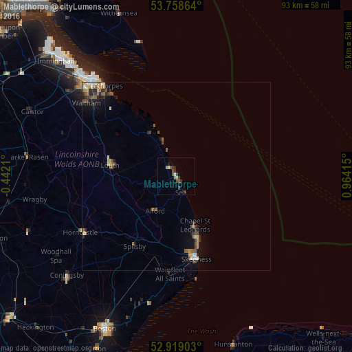
Mablethorpe night lights from space
Night Light of Mablethorpe (England) from space (United Kingdom) Src. Average luminocity for 10x10km area is 5.8043% and for 50x50km: 2.1605%.
Analysis of Mablethorpe night lights 2016
Square area 10x10 km:
 0.25%
0.25%90-99
0.63%80-89
0.25%70-79
0.88%60-69
0.51%50-59
1.01%40-49
2.02%30-39
1.52%20-29
2.15%10-19
1.14%0-9
89.65%Square area 50x50 km:
0.12%90-99
0.32%80-89
0.2%70-79
0.29%60-69
0.35%50-59
0.49%40-49
0.43%30-39
0.28%20-29
0.63%10-19
0.98%0-9
95.91%Clear (daylight) street map image can be seen on geolist.org.
Map coordinates:
53° 45' 31.1" North, 0° 26' 31.6" West
53° 20' 27.2" North, 0° 15' 39.7" East
52° 55' 8.5" North, 0° 57' 50.9" East
Some cities around Mablethorpe sort by population:
• Grimsby
33.5 km =20.8 mi,  318°
318°
• Cleethorpes
31.2 km =19.4 mi, 321°
• Skegness
22.5 km =14 mi,  167°
167°
• Louth
17.8 km =11.1 mi,  279°
279°
• Humberston
28.3 km =17.6 mi, 318°
• Horncastle
29.2 km =18.1 mi,  239°
239°
• Waltham
30.9 km =19.2 mi,  309°
309°
• Burwell
16 km =9.9 mi,  250°
250°
2643269 (p: 12,531)
Sources (retrieved 2019-11-25):
» Earth at Night: Flat Maps 2012, 2016