Louth night lights from space
Night Light of Louth (England) from space (United Kingdom) Src. Average luminocity for 10x10km area is 4.422% and for 50x50km: 3.2647%.
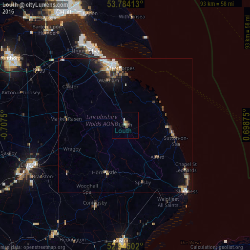
Analysis of Louth night lights 2016
Square area 10x10 km:
 0.4%
0.4%90-99
0.66%80-89
0.53%70-79
1.06%60-69
0.26%50-59
0.53%40-49
1.85%30-39
0%20-29
0.4%10-19
0.13%0-9
94.18%Square area 50x50 km:
0.37%90-99
0.57%80-89
0.26%70-79
0.34%60-69
0.51%50-59
0.57%40-49
0.52%30-39
0.41%20-29
1.06%10-19
1.92%0-9
93.46%Clear (daylight) street map image can be seen on geolist.org.
Map coordinates:
53° 47' 2.9" North, 0° 42' 27" West
53° 21' 59.9" North, 0° 0' 15.8" West
52° 56' 42.1" North, 0° 41' 55.5" East
Some cities around Louth sort by population:
• Grimsby
22.6 km =14 mi,  347°
347°
• Cleethorpes
21.6 km =13.4 mi,  355°
355°
• Mablethorpe
17.8 km =11.1 mi,  99°
99°
• Immingham
30.9 km =19.2 mi,  333°
333°
• Humberston
18.3 km =11.4 mi, 355°
• Horncastle
19.2 km =11.9 mi,  202°
202°
• Waltham
17.8 km =11.1 mi,  339°
339°
• Burwell
8.6 km =5.3 mi,  162°
162°
2643553 (p: 16,419)
Sources (retrieved 2019-11-25):
» Earth at Night: Flat Maps 2012, 2016