Immingham night lights from space
Night Light of Immingham (England) from space (United Kingdom) Src. Average luminocity for 10x10km area is 39.1098% and for 50x50km: 11.0611%.
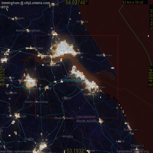
Analysis of Immingham night lights 2016
Square area 10x10 km:
 12.37%
90-99
10.23%80-89
1.01%70-79
1.77%60-69
1.77%50-59
2.78%40-49
4.8%30-39
2.65%20-29
19.7%10-19
24.37%0-9
18.56%Square area 50x50 km:
2.25%90-99
2.37%80-89
0.74%70-79
0.7%60-69
0.93%50-59
1.36%40-49
1.12%30-39
1.63%20-29
4.47%10-19
8.29%0-9
76.15%Clear (daylight) street map image can be seen on geolist.org.
Map coordinates:
54° 1' 38.9" North, 0° 55' 31.2" West
53° 36' 51.1" North, 0° 12' 56.8" West
53° 11' 35.5" North, 0° 28' 51.4" East
Some cities around Immingham sort by population:
• Kingston upon Hull
16.5 km =10.3 mi,  331°
331°
• Grimsby
10.7 km =6.6 mi,  120°
120°
• Cleethorpes
13.5 km =8.4 mi, 116°
• Barton upon Humber
17.2 km =10.7 mi,  299°
299°
• Hedon
14 km =8.7 mi,  5°
5°
• Humberston
15.7 km =9.8 mi,  126°
126°
• Brigg
19.5 km =12.1 mi,  249°
249°
• Waltham
13.3 km =8.3 mi,  144°
144°
2646256 (p: 10,750)
Sources (retrieved 2019-11-25):
» Earth at Night: Flat Maps 2012, 2016