Longridge night lights from space
Night Light of Longridge (England) from space (United Kingdom) Src. Average luminocity for 10x10km area is 9.1653% and for 50x50km: 15.2012%.
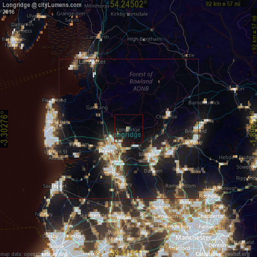
Analysis of Longridge night lights 2016
Square area 10x10 km:
 0.66%
0.66%90-99
0.93%80-89
0.26%70-79
0.79%60-69
1.85%50-59
0.4%40-49
0.4%30-39
0.93%20-29
5.16%10-19
13.36%0-9
75.26%Square area 50x50 km:
1.82%90-99
2.46%80-89
1.03%70-79
1.55%60-69
2.21%50-59
2.02%40-49
1.96%30-39
2.2%20-29
5.63%10-19
16.19%0-9
62.92%Clear (daylight) street map image can be seen on geolist.org.
Map coordinates:
54° 14' 42.1" North, 3° 18' 9.9" West
53° 49' 55.6" North, 2° 35' 58.7" West
53° 24' 54.4" North, 1° 53' 47.4" West
Some cities around Longridge sort by population:
• Preston
10.3 km =6.4 mi,  221°
221°
• Blackburn
11.9 km =7.4 mi,  140°
140°
• Clitheroe
13.6 km =8.5 mi,  73°
73°
• Clayton-le-Woods
15.7 km =9.8 mi,  196°
196°
• Great Harwood
13.6 km =8.5 mi,  112°
112°
• Garstang
13.8 km =8.6 mi,  303°
303°
• Clayton le Moors
16 km =9.9 mi,  117°
117°
• Rishton
14.1 km =8.8 mi, 120°
2643646 (p: 7,526)
Sources (retrieved 2019-11-25):
» Earth at Night: Flat Maps 2012, 2016