Great Harwood night lights from space
Night Light of Great Harwood (England) from space (United Kingdom) Src. Average luminocity for 10x10km area is 38.627% and for 50x50km: 20.3698%.
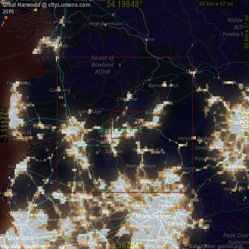
Analysis of Great Harwood night lights 2016
Square area 10x10 km:
 7.28%
7.28%90-99
7.8%80-89
1.85%70-79
3.97%60-69
5.42%50-59
5.03%40-49
6.08%30-39
6.75%20-29
14.02%10-19
27.78%0-9
14.02%Square area 50x50 km:
2.94%90-99
3.72%80-89
1.56%70-79
2.25%60-69
3.37%50-59
2.89%40-49
2.81%30-39
2.78%20-29
7.22%10-19
15.7%0-9
54.77%Clear (daylight) street map image can be seen on geolist.org.
Map coordinates:
54° 11' 54.5" North, 3° 6' 42.4" West
53° 47' 6.4" North, 2° 24' 31.1" West
53° 22' 3.5" North, 1° 42' 19.9" West
Some cities around Great Harwood sort by population:
• Blackburn
6.3 km =3.9 mi,  231°
231°
• Accrington
4.8 km =3 mi,  136°
136°
• Darwen
10.4 km =6.5 mi,  200°
200°
• Haslingden
10.7 km =6.6 mi,  148°
148°
• Clitheroe
9.1 km =5.7 mi,  3°
3°
• Padiham
6.4 km =4 mi,  73°
73°
• Clayton le Moors
2.6 km =1.6 mi, 140°
• Rishton
1.9 km =1.2 mi,  191°
191°
2648084 (p: 11,467)
Sources (retrieved 2019-11-25):
» Earth at Night: Flat Maps 2012, 2016