Clayton le Moors night lights from space
Night Light of Clayton le Moors (England) from space (United Kingdom) Src. Average luminocity for 10x10km area is 41.8108% and for 50x50km: 23.5285%.
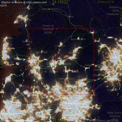
Analysis of Clayton le Moors night lights 2016
Square area 10x10 km:
 6.61%
6.61%90-99
7.54%80-89
2.51%70-79
5.29%60-69
5.69%50-59
5.03%40-49
6.88%30-39
7.41%20-29
20.11%10-19
32.8%0-9
0.13%Square area 50x50 km:
3.67%90-99
4.67%80-89
1.99%70-79
2.79%60-69
3.98%50-59
3.17%40-49
3.1%30-39
3.08%20-29
7.47%10-19
15.12%0-9
50.96%Clear (daylight) street map image can be seen on geolist.org.
Map coordinates:
54° 10' 48.8" North, 3° 5' 11.3" West
53° 46' 0" North, 2° 22' 60" West
53° 20' 56.4" North, 1° 40' 48.8" West
Some cities around Clayton le Moors sort by population:
• Blackburn
6.8 km =4.2 mi,  254°
254°
• Accrington
2.2 km =1.4 mi,  131°
131°
• Darwen
9.3 km =5.8 mi,  215°
215°
• Rawtenstall
9.8 km =6.1 mi,  138°
138°
• Haslingden
8.1 km =5 mi,  150°
150°
• Great Harwood
2.6 km =1.6 mi,  320°
320°
• Padiham
6 km =3.7 mi,  48°
48°
• Rishton
2.1 km =1.3 mi,  274°
274°
2652899 (p: 8,474)
Sources (retrieved 2019-11-25):
» Earth at Night: Flat Maps 2012, 2016