Clitheroe night lights from space
Night Light of Clitheroe (England) from space (United Kingdom) Src. Average luminocity for 10x10km area is 8.9987% and for 50x50km: 12.4966%.
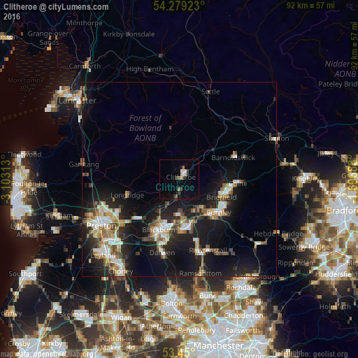
Analysis of Clitheroe night lights 2016
Square area 10x10 km:
 1.19%
1.19%90-99
1.46%80-89
0.13%70-79
1.06%60-69
0.93%50-59
1.06%40-49
0.53%30-39
3.17%20-29
0.13%10-19
1.72%0-9
88.62%Square area 50x50 km:
1.66%90-99
2.23%80-89
0.87%70-79
1.51%60-69
1.84%50-59
1.47%40-49
1.55%30-39
1.59%20-29
3.9%10-19
12.43%0-9
70.94%Clear (daylight) street map image can be seen on geolist.org.
Map coordinates:
54° 16' 45.2" North, 3° 6' 11.3" West
53° 52' 0" North, 2° 24' 0" West
53° 27' 0" North, 1° 41' 48.8" West
Some cities around Clitheroe sort by population:
• Burnley
13.2 km =8.2 mi,  124°
124°
• Accrington
12.8 km =8 mi,  167°
167°
• Great Harwood
9.1 km =5.7 mi,  183°
183°
• Padiham
9.1 km =5.7 mi,  142°
142°
• Brierfield
11.8 km =7.3 mi,  113°
113°
• Clayton le Moors
11.2 km =7 mi, 174°
• Rishton
11 km =6.8 mi, 184°
• Barrowford
12.1 km =7.5 mi,  100°
100°
2652819 (p: 14,765)
Sources (retrieved 2019-11-25):
» Earth at Night: Flat Maps 2012, 2016