Brynna night lights from space
Night Light of Brynna (Wales) from space (United Kingdom) Src. Average luminocity for 10x10km area is 15.0107% and for 50x50km: 16.504%.
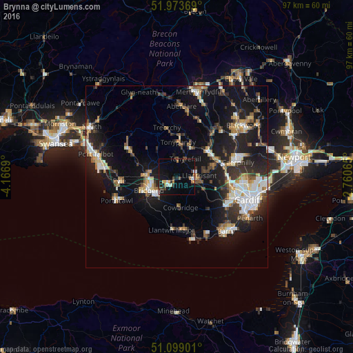
Analysis of Brynna night lights 2016
Square area 10x10 km:
 1.34%
1.34%90-99
2.27%80-89
0.27%70-79
2.01%60-69
2.54%50-59
0.4%40-49
2.67%30-39
2.01%20-29
1.2%10-19
15.51%0-9
69.79%Square area 50x50 km:
2.51%90-99
3.01%80-89
1.34%70-79
1.81%60-69
1.82%50-59
1.79%40-49
1.94%30-39
2.62%20-29
5.41%10-19
14.78%0-9
62.98%Clear (daylight) street map image can be seen on geolist.org.
Map coordinates:
51° 58' 25.3" North, 4° 10' 0.8" West
51° 32' 18.4" North, 3° 27' 49.6" West
51° 5' 56.4" North, 2° 45' 38.3" West
Some cities around Brynna sort by population:
• Bridgend
8.6 km =5.3 mi,  245°
245°
• Coity
6.6 km =4.1 mi, 253°
• Llantrisant
6.2 km =3.9 mi,  88°
88°
• Tonyrefail
5.6 km =3.5 mi,  24°
24°
• Pencoed
3 km =1.9 mi,  236°
236°
• Beddau
7.5 km =4.7 mi,  76°
76°
• Pontyclun
5.3 km =3.3 mi,  110°
110°
• Llanharan
1.7 km =1.1 mi, 91°
3345314 (p: 6,686)
Sources (retrieved 2019-11-25):
» Earth at Night: Flat Maps 2012, 2016