Broxburn night lights from space
Night Light of Broxburn (Scotland) from space (United Kingdom) Src. Average luminocity for 10x10km area is 44.0213% and for 50x50km: 21.9589%.
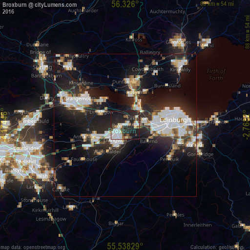
Analysis of Broxburn night lights 2016
Square area 10x10 km:
 11.28%
90-99
10.15%80-89
4.26%70-79
1.88%60-69
3.26%50-59
4.14%40-49
3.38%30-39
3.51%20-29
27.32%10-19
28.07%0-9
2.76%Square area 50x50 km:
4.62%90-99
5.03%80-89
1.79%70-79
1.73%60-69
1.99%50-59
1.85%40-49
2.03%30-39
2.57%20-29
9%10-19
16.4%0-9
52.98%Clear (daylight) street map image can be seen on geolist.org.
Map coordinates:
56° 19' 33.6" North, 4° 10' 28.1" West
55° 56' 2.9" North, 3° 28' 16.8" West
55° 32' 17.8" North, 2° 46' 5.5" West
Some cities around Broxburn sort by population:
• Livingston
4.7 km =2.9 mi,  222°
222°
• Bathgate
11.3 km =7 mi,  251°
251°
• Rosyth
11.6 km =7.2 mi,  10°
10°
• Linlithgow
9.5 km =5.9 mi,  299°
299°
• Queensferry
7.8 km =4.8 mi,  35°
35°
• Currie
11 km =6.8 mi,  112°
112°
• Balerno
9.9 km =6.2 mi,  124°
124°
• Inverkeithing
12 km =7.5 mi,  23°
23°
2654480 (p: 15,360)
Sources (retrieved 2019-11-25):
» Earth at Night: Flat Maps 2012, 2016