Lanark night lights from space
Night Light of Lanark (Scotland) from space (United Kingdom) Src. Average luminocity for 10x10km area is 4.8756% and for 50x50km: 12.8481%.
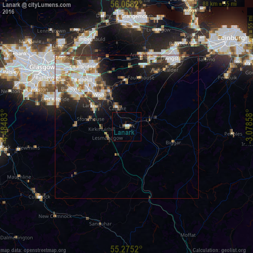
Analysis of Lanark night lights 2016
Square area 10x10 km:
 0.72%
0.72%90-99
0.72%80-89
0%70-79
0.48%60-69
1.67%50-59
0.24%40-49
0%30-39
0.96%20-29
0.6%10-19
0.12%0-9
94.5%Square area 50x50 km:
2.93%90-99
3.15%80-89
0.91%70-79
1.58%60-69
1.45%50-59
1.47%40-49
1.5%30-39
1.64%20-29
2.99%10-19
4.73%0-9
77.64%Clear (daylight) street map image can be seen on geolist.org.
Map coordinates:
56° 4' 5.5" North, 4° 29' 5.4" West
55° 40' 25.4" North, 3° 46' 54.1" West
55° 16' 30.7" North, 3° 4' 42.9" West
Some cities around Lanark sort by population:
• Wishaw
13.4 km =8.3 mi,  320°
320°
• Dalserf
10.7 km =6.6 mi,  308°
308°
• Larkhall
13.4 km =8.3 mi,  299°
299°
• Carluke
7.6 km =4.7 mi,  336°
336°
• Shotts
16.2 km =10.1 mi,  356°
356°
• Strathaven
17.9 km =11.1 mi,  271°
271°
• Newmains
13.7 km =8.5 mi,  334°
334°
• Stonehouse
13.1 km =8.1 mi,  280°
280°
2644976 (p: 8,890)
Sources (retrieved 2019-11-25):
» Earth at Night: Flat Maps 2012, 2016