Hale night lights from space
Night Light of Hale (England) from space (United Kingdom) Src. Average luminocity for 10x10km area is 62.6812% and for 50x50km: 42.9419%.
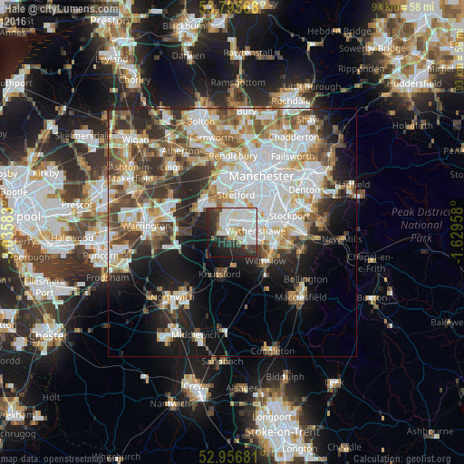
Analysis of Hale night lights 2016
Square area 10x10 km:
100  22.09%
90-99 21.83%
80-89 3.7%
70-79 2.25%
60-69 2.78%
50-59 2.78%
40-49 4.1%
30-39 10.98%
20-29 16.67%
10-19 10.71%
0-9 2.12%
22.09%90-99
21.83%80-89
3.7%70-79
2.25%60-69
2.78%50-59
2.78%40-49
4.1%30-39
10.98%20-29
16.67%10-19
10.71%0-9
2.12%Square area 50x50 km:
100 11.68%
90-99 9.8%
80-89 4.71%
70-79 4.55%
60-69 4.94%
50-59 4.99%
40-49 5.79%
30-39 5.46%
20-29 7.37%
10-19 11.15%
0-9 29.55%
11.68%90-99
9.8%80-89
4.71%70-79
4.55%60-69
4.94%50-59
4.99%40-49
5.79%30-39
5.46%20-29
7.37%10-19
11.15%0-9
29.55%Clear (daylight) street map image can be seen on geolist.org.
Map coordinates:
53° 47' 44.4" North, 3° 2' 9" West
53° 22' 41.9" North, 2° 19' 57.8" West
52° 57' 24.5" North, 1° 37' 46.5" West
Some cities around Hale sort by population:
• Sale
5.2 km =3.2 mi,  6°
6°
• Stretford
8 km =5 mi, 7°
• Altrincham
1.5 km =0.9 mi,  314°
314°
• Urmston
7.9 km =4.9 mi,  349°
349°
• Didsbury
8 km =5 mi,  57°
57°
• Timperley
2.4 km =1.5 mi,  359°
359°
• Partington
7.8 km =4.8 mi, 305°
• Bowdon
2.2 km =1.4 mi,  264°
264°
6640028 (p: 15,315)
Sources (retrieved 2019-11-25):
» Earth at Night: Flat Maps 2012, 2016