Knottingley night lights from space
Night Light of Knottingley (England) from space (United Kingdom) Src. Average luminocity for 10x10km area is 40.1111% and for 50x50km: 31.7151%.
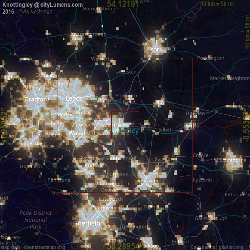
Analysis of Knottingley night lights 2016
Square area 10x10 km:
 12.5%
12.5%90-99
10.61%80-89
2.27%70-79
3.41%60-69
1.77%50-59
2.27%40-49
1.64%30-39
5.81%20-29
16.04%10-19
17.68%0-9
26.01%Square area 50x50 km:
8.1%90-99
7.1%80-89
2.51%70-79
2.92%60-69
2.77%50-59
3.39%40-49
3.51%30-39
5.95%20-29
9.44%10-19
11.66%0-9
42.65%Clear (daylight) street map image can be seen on geolist.org.
Map coordinates:
54° 7' 18.9" North, 1° 57' 34.3" West
53° 42' 28" North, 1° 15' 23" West
53° 17' 22.3" North, 0° 33' 11.8" West
Some cities around Knottingley sort by population:
• Castleford
7.3 km =4.5 mi,  286°
286°
• Pontefract
4.1 km =2.5 mi,  243°
243°
• South Elmsall
12.4 km =7.7 mi,  187°
187°
• Kippax
10 km =6.2 mi,  311°
311°
• Featherstone
7.4 km =4.6 mi, 242°
• Sherburn in Elmet
9.7 km =6 mi,  3°
3°
• Upton
10.5 km =6.5 mi, 190°
• Askern
12.3 km =7.6 mi,  146°
146°
2645102 (p: 13,804)
Sources (retrieved 2019-11-25):
» Earth at Night: Flat Maps 2012, 2016