Maltby night lights from space
Night Light of Maltby (England) from space (United Kingdom) Src. Average luminocity for 10x10km area is 19.5093% and for 50x50km: 28.184%.
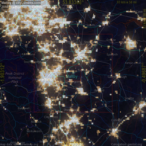
Analysis of Maltby night lights 2016
Square area 10x10 km:
 1.32%
1.32%90-99
1.85%80-89
1.98%70-79
1.46%60-69
2.38%50-59
1.98%40-49
2.25%30-39
1.59%20-29
4.37%10-19
45.37%0-9
35.45%Square area 50x50 km:
4.43%90-99
5.16%80-89
2.88%70-79
3.17%60-69
3.14%50-59
3.69%40-49
3.61%30-39
5.81%20-29
11.59%10-19
16.85%0-9
39.67%Clear (daylight) street map image can be seen on geolist.org.
Map coordinates:
53° 50' 1.2" North, 1° 54' 11.2" West
53° 25' 0" North, 1° 12' 0" West
52° 59' 44" North, 0° 29' 48.7" West
Some cities around Maltby sort by population:
• Rotherham
10.5 km =6.5 mi,  278°
278°
• Dinnington
5.6 km =3.5 mi,  180°
180°
• Rawmarsh
10.7 km =6.6 mi,  297°
297°
• Conisbrough
7.6 km =4.7 mi,  343°
343°
• Mexborough
10.5 km =6.5 mi,  324°
324°
• Kiveton Park
9.1 km =5.7 mi,  203°
203°
• Bircotes
10 km =6.2 mi,  88°
88°
• Wales
10 km =6.2 mi,  212°
212°
2643144 (p: 17,513)
Sources (retrieved 2019-11-25):
» Earth at Night: Flat Maps 2012, 2016