Dinnington night lights from space
Night Light of Dinnington (England) from space (United Kingdom) Src. Average luminocity for 10x10km area is 18.422% and for 50x50km: 27.3484%.
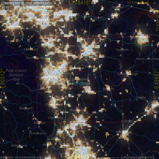
Analysis of Dinnington night lights 2016
Square area 10x10 km:
 1.46%
1.46%90-99
1.46%80-89
1.06%70-79
1.19%60-69
2.78%50-59
3.7%40-49
2.25%30-39
2.38%20-29
2.65%10-19
35.05%0-9
46.03%Square area 50x50 km:
4.33%90-99
5.24%80-89
2.82%70-79
3.03%60-69
3.09%50-59
3.51%40-49
3.53%30-39
5.32%20-29
10.23%10-19
16.65%0-9
42.24%Clear (daylight) street map image can be seen on geolist.org.
Map coordinates:
53° 47' 3" North, 1° 54' 11.2" West
53° 22' 0" North, 1° 12' 0" West
52° 56' 42.2" North, 0° 29' 48.7" West
Some cities around Dinnington sort by population:
• Worksop
8.8 km =5.5 mi,  145°
145°
• Maltby
5.6 km =3.5 mi,  0°
0°
• Beighton
9.6 km =6 mi,  247°
247°
• Killamarsh
9.1 km =5.7 mi,  238°
238°
• Kiveton Park
4.6 km =2.9 mi,  232°
232°
• Bircotes
11.6 km =7.2 mi,  59°
59°
• Clowne
11.1 km =6.9 mi,  202°
202°
• Wales
6.1 km =3.8 mi, 241°
2651241 (p: 19,860)
Sources (retrieved 2019-11-25):
» Earth at Night: Flat Maps 2012, 2016