Beighton night lights from space
Night Light of Beighton (England) from space (United Kingdom) Src. Average luminocity for 10x10km area is 42.5227% and for 50x50km: 26.4905%.
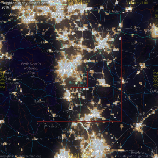
Analysis of Beighton night lights 2016
Square area 10x10 km:
 2.9%
2.9%90-99
6.94%80-89
5.43%70-79
5.68%60-69
7.7%50-59
9.97%40-49
5.3%30-39
5.56%20-29
25.13%10-19
23.61%0-9
1.77%Square area 50x50 km:
4.44%90-99
5.27%80-89
2.76%70-79
2.84%60-69
2.97%50-59
3.26%40-49
3.44%30-39
5.08%20-29
9.19%10-19
15.55%0-9
45.2%Clear (daylight) street map image can be seen on geolist.org.
Map coordinates:
53° 45' 4.1" North, 2° 2' 11.2" West
53° 19' 60" North, 1° 19' 60" West
52° 54' 41" North, 0° 37' 48.7" West
Some cities around Beighton sort by population:
• Sheffield
10.4 km =6.5 mi,  302°
302°
• Staveley
7.5 km =4.7 mi,  188°
188°
• Dronfield
10 km =6.2 mi,  249°
249°
• Dinnington
9.6 km =6 mi,  67°
67°
• Killamarsh
1.5 km =0.9 mi,  133°
133°
• Kiveton Park
5.3 km =3.3 mi,  80°
80°
• Clowne
8 km =5 mi,  144°
144°
• Wales
3.5 km =2.2 mi, 76°
2656000 (p: 10,914)
Sources (retrieved 2019-11-25):
» Earth at Night: Flat Maps 2012, 2016