Killamarsh night lights from space
Night Light of Killamarsh (England) from space (United Kingdom) Src. Average luminocity for 10x10km area is 37.7374% and for 50x50km: 26.5603%.
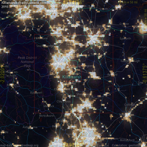
Analysis of Killamarsh night lights 2016
Square area 10x10 km:
 2.65%
2.65%90-99
5.68%80-89
3.66%70-79
4.92%60-69
7.07%50-59
9.6%40-49
5.18%30-39
4.04%20-29
20.45%10-19
26.52%0-9
10.23%Square area 50x50 km:
4.46%90-99
5.13%80-89
2.82%70-79
2.84%60-69
3%50-59
3.37%40-49
3.46%30-39
5.06%20-29
9.21%10-19
15.54%0-9
45.1%Clear (daylight) street map image can be seen on geolist.org.
Map coordinates:
53° 44' 30.7" North, 2° 1' 12" West
53° 19' 26.2" North, 1° 19' 0.8" West
52° 54' 6.9" North, 0° 36' 49.5" West
Some cities around Killamarsh sort by population:
• Chesterfield
10.6 km =6.6 mi,  218°
218°
• Staveley
6.7 km =4.2 mi,  199°
199°
• Dinnington
9.1 km =5.7 mi,  58°
58°
• Beighton
1.5 km =0.9 mi,  313°
313°
• Kiveton Park
4.5 km =2.8 mi, 64°
• Clowne
6.5 km =4 mi,  147°
147°
• Wales
3 km =1.9 mi,  51°
51°
• Creswell
9.4 km =5.8 mi,  136°
136°
2645653 (p: 9,625)
Sources (retrieved 2019-11-25):
» Earth at Night: Flat Maps 2012, 2016