Hurstpierpoint night lights from space
Night Light of Hurstpierpoint (England) from space (United Kingdom) Src. Average luminocity for 10x10km area is 13.2325% and for 50x50km: 9.5261%.
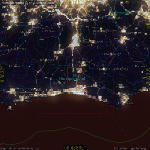
Analysis of Hurstpierpoint night lights 2016
Square area 10x10 km:
 0.14%
0.14%90-99
0.42%80-89
0.56%70-79
1.12%60-69
1.96%50-59
4.76%40-49
3.36%30-39
3.22%20-29
0.42%10-19
17.09%0-9
66.95%Square area 50x50 km:
1.04%90-99
1.43%80-89
0.82%70-79
1.03%60-69
1.19%50-59
1.49%40-49
1.77%30-39
1.26%20-29
2.29%10-19
7.78%0-9
79.9%Clear (daylight) street map image can be seen on geolist.org.
Map coordinates:
51° 22' 29.6" North, 0° 52' 59.5" West
50° 56' 2" North, 0° 10' 48.3" West
50° 29' 19.1" North, 0° 31' 23" East
Some cities around Hurstpierpoint sort by population:
• Brighton
12.1 km =7.5 mi,  166°
166°
• Hove
11.5 km =7.1 mi,  175°
175°
• Haywards Heath
8.9 km =5.5 mi,  37°
37°
• Burgess Hill
4.3 km =2.7 mi,  50°
50°
• Portslade
10.4 km =6.5 mi,  194°
194°
• Shoreham-by-Sea
12.9 km =8 mi,  210°
210°
• Steyning
11.6 km =7.2 mi,  243°
243°
• Hassocks
1.2 km =0.7 mi,  123°
123°
2646355 (p: 12,730)
Sources (retrieved 2019-11-25):
» Earth at Night: Flat Maps 2012, 2016