Steyning night lights from space
Night Light of Steyning (England) from space (United Kingdom) Src. Average luminocity for 10x10km area is 7.1975% and for 50x50km: 8.5654%.
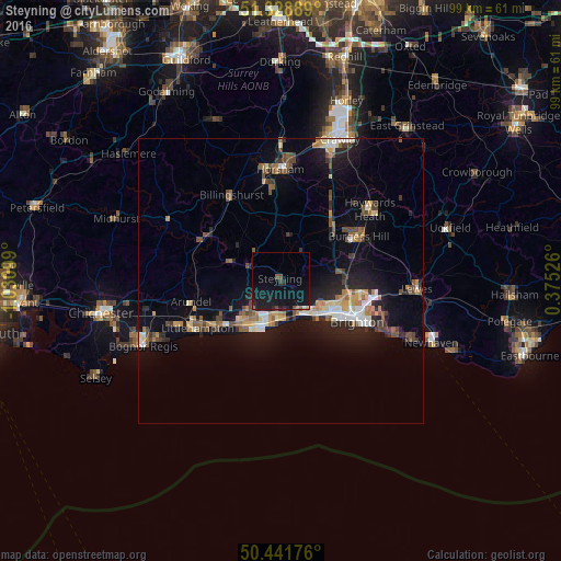
Analysis of Steyning night lights 2016
Square area 10x10 km:
 0%
0%90-99
0%80-89
0.28%70-79
0.14%60-69
0.42%50-59
1.12%40-49
0.98%30-39
0.7%20-29
1.68%10-19
21.29%0-9
73.39%Square area 50x50 km:
0.74%90-99
1.09%80-89
0.85%70-79
1.08%60-69
1.12%50-59
1.35%40-49
1.54%30-39
1.06%20-29
2%10-19
7.35%0-9
81.81%Clear (daylight) street map image can be seen on geolist.org.
Map coordinates:
51° 19' 44" North, 1° 1' 51.6" West
50° 53' 14.8" North, 0° 19' 40.3" West
50° 26' 30.3" North, 0° 22' 30.9" East
Some cities around Steyning sort by population:
• Worthing
8.4 km =5.2 mi,  203°
203°
• Portslade
9.3 km =5.8 mi,  122°
122°
• Shoreham-by-Sea
7 km =4.3 mi,  147°
147°
• Lancing
6.5 km =4 mi,  176°
176°
• Hurstpierpoint
11.6 km =7.2 mi,  63°
63°
• Storrington
9.5 km =5.9 mi,  290°
290°
• Broadwater
7.3 km =4.5 mi,  207°
207°
• Hassocks
12.2 km =7.6 mi,  68°
68°
2636928 (p: 9,627)
Sources (retrieved 2019-11-25):
» Earth at Night: Flat Maps 2012, 2016