Haywards Heath night lights from space
Night Light of Haywards Heath (England) from space (United Kingdom) Src. Average luminocity for 10x10km area is 12.3904% and for 50x50km: 10.4739%.

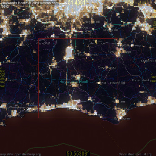
Analysis of Haywards Heath night lights 2016
Square area 10x10 km:
 0.13%
0.13%90-99
0.67%80-89
2.14%70-79
1.34%60-69
1.74%50-59
3.21%40-49
5.35%30-39
0.94%20-29
0.8%10-19
3.07%0-9
80.61%Square area 50x50 km:
1.1%90-99
1.51%80-89
0.8%70-79
1.16%60-69
1.36%50-59
1.5%40-49
1.98%30-39
1.72%20-29
2.83%10-19
9.22%0-9
76.83%Clear (daylight) street map image can be seen on geolist.org.
Map coordinates:
51° 26' 17.2" North, 0° 48' 22.5" West
50° 59' 51.7" North, 0° 6' 11.3" West
50° 33' 11" North, 0° 36' 0" East
Some cities around Haywards Heath sort by population:
• Crawley
14 km =8.7 mi,  336°
336°
• Burgess Hill
4.8 km =3 mi,  205°
205°
• Uckfield
14.3 km =8.9 mi,  102°
102°
• Broadfield
13.2 km =8.2 mi,  326°
326°
• Hurstpierpoint
8.9 km =5.5 mi,  217°
217°
• Maidenbower
12.7 km =7.9 mi, 344°
• Hassocks
8.9 km =5.5 mi, 209°
• Furnace Green
13 km =8.1 mi, 339°
2647248 (p: 33,845)
Sources (retrieved 2019-11-25):
» Earth at Night: Flat Maps 2012, 2016