Heysham night lights from space
Night Light of Heysham (England) from space (United Kingdom) Src. Average luminocity for 10x10km area is 21.3851% and for 50x50km: 5.8145%.
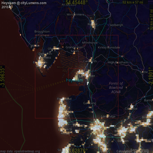
Analysis of Heysham night lights 2016
Square area 10x10 km:
 3.03%
3.03%90-99
3.03%80-89
0.88%70-79
2.53%60-69
4.29%50-59
4.04%40-49
3.16%30-39
0.76%20-29
3.16%10-19
24.75%0-9
50.38%Square area 50x50 km:
0.72%90-99
0.93%80-89
0.43%70-79
0.69%60-69
0.74%50-59
0.95%40-49
0.9%30-39
0.49%20-29
1.42%10-19
5.35%0-9
87.38%Clear (daylight) street map image can be seen on geolist.org.
Map coordinates:
54° 27' 16.1" North, 3° 35' 46.9" West
54° 2' 37.2" North, 2° 53' 35.6" West
53° 37' 43.5" North, 2° 11' 24.4" West
Some cities around Heysham sort by population:
• Morecambe
3.5 km =2.2 mi,  37°
37°
• Lancaster
6.1 km =3.8 mi,  87°
87°
• Thornton-Cleveleys
20.7 km =12.9 mi,  204°
204°
• Fleetwood
15.2 km =9.4 mi,  210°
210°
• Garstang
17.7 km =11 mi,  153°
153°
• Carnforth
12.7 km =7.9 mi, 39°
• Bolton le Sands
8.4 km =5.2 mi,  46°
46°
• Preesall
14.7 km =9.1 mi, 198°
2647001 (p: 17,016)
Sources (retrieved 2019-11-25):
» Earth at Night: Flat Maps 2012, 2016