Carnforth night lights from space
Night Light of Carnforth (England) from space (United Kingdom) Src. Average luminocity for 10x10km area is 5.5126% and for 50x50km: 2.8806%.
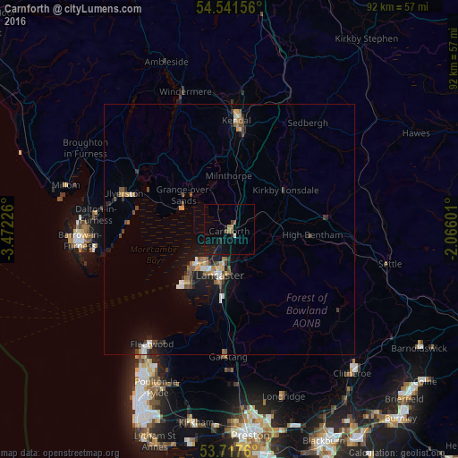
Analysis of Carnforth night lights 2016
Square area 10x10 km:
 0%
0%90-99
0.51%80-89
0%70-79
0.13%60-69
1.39%50-59
0.76%40-49
1.26%30-39
0%20-29
1.52%10-19
8.71%0-9
85.73%Square area 50x50 km:
0.25%90-99
0.39%80-89
0.18%70-79
0.38%60-69
0.41%50-59
0.51%40-49
0.55%30-39
0.29%20-29
0.53%10-19
2.5%0-9
94.02%Clear (daylight) street map image can be seen on geolist.org.
Map coordinates:
54° 32' 29.6" North, 3° 28' 20.1" West
54° 7' 53.9" North, 2° 46' 8.9" West
53° 43' 3.4" North, 2° 3' 57.6" West
Some cities around Carnforth sort by population:
• Morecambe
9.2 km =5.7 mi,  220°
220°
• Lancaster
9.7 km =6 mi,  191°
191°
• Kendal
21.7 km =13.5 mi,  3°
3°
• Heysham
12.7 km =7.9 mi, 219°
• Ulverston
22.5 km =14 mi,  288°
288°
• Garstang
25.7 km =16 mi,  180°
180°
• Dalton in Furness
26.9 km =16.7 mi,  276°
276°
• Bolton le Sands
4.4 km =2.7 mi,  207°
207°
2653715 (p: 7,920)
Sources (retrieved 2019-11-25):
» Earth at Night: Flat Maps 2012, 2016