Thornton-Cleveleys night lights from space
Night Light of Thornton-Cleveleys (England) from space (United Kingdom) Src. Average luminocity for 10x10km area is 43.0873% and for 50x50km: 11.2347%.
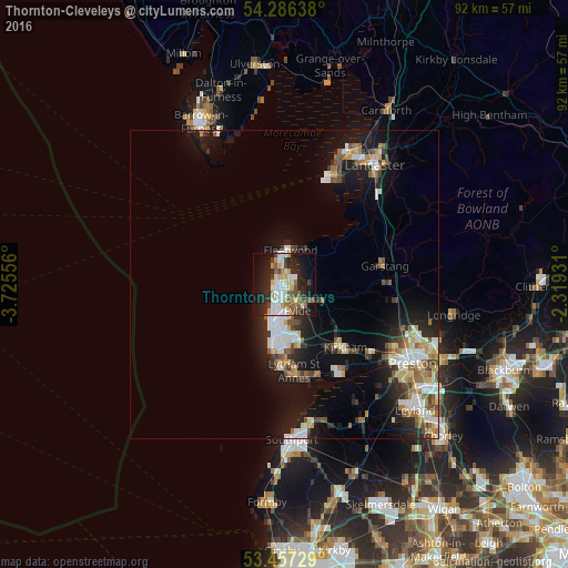

Analysis of Thornton-Cleveleys night lights 2016
Square area 10x10 km:
 7.14%
7.14%90-99
10.05%80-89
5.29%70-79
6.75%60-69
2.91%50-59
6.22%40-49
5.16%30-39
3.17%20-29
16.01%10-19
26.19%0-9
11.11%Square area 50x50 km:
1.82%90-99
2.27%80-89
1.03%70-79
1.18%60-69
1.42%50-59
1.45%40-49
1.34%30-39
1.17%20-29
3.07%10-19
8.76%0-9
76.49%Clear (daylight) street map image can be seen on geolist.org.
Map coordinates:
54° 17' 11" North, 3° 43' 32" West
53° 52' 26" North, 3° 1' 20.8" West
53° 27' 26.2" North, 2° 19' 9.5" West
Some cities around Thornton-Cleveleys sort by population:
• Blackpool
6.6 km =4.1 mi,  195°
195°
• Fylde
8.3 km =5.2 mi,  123°
123°
• Lytham St Annes
14.7 km =9.1 mi,  173°
173°
• Fleetwood
5.8 km =3.6 mi,  7°
7°
• Poulton-le-Fylde
5.2 km =3.2 mi,  150°
150°
• Cleveleys
1.2 km =0.7 mi,  289°
289°
• Kirkham
14.2 km =8.8 mi,  135°
135°
• Preesall
6.1 km =3.8 mi,  36°
36°
8299615 (p: 31,157)
Sources (retrieved 2019-11-25):
» Earth at Night: Flat Maps 2012, 2016