Hadleigh night lights from space
Night Light of Hadleigh (England) from space (United Kingdom) Src. Average luminocity for 10x10km area is 45.2821% and for 50x50km: 22.3366%.
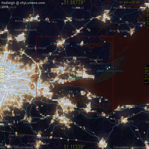
Analysis of Hadleigh night lights 2016
Square area 10x10 km:
 1.87%
1.87%90-99
6.28%80-89
6.15%70-79
6.55%60-69
5.61%50-59
9.36%40-49
13.9%30-39
14.84%20-29
23.26%10-19
12.03%0-9
0.13%Square area 50x50 km:
3.17%90-99
4.02%80-89
2.49%70-79
2.51%60-69
2.63%50-59
2.55%40-49
3.59%30-39
4.17%20-29
8.19%10-19
15.5%0-9
51.18%Clear (daylight) street map image can be seen on geolist.org.
Map coordinates:
51° 59' 16" North, 0° 5' 35.9" West
51° 33' 9.7" North, 0° 36' 35.4" East
51° 6' 48.2" North, 1° 18' 46.6" East
Some cities around Hadleigh sort by population:
• Southend-on-Sea
7.4 km =4.6 mi,  102°
102°
• Basildon
10.7 km =6.6 mi,  279°
279°
• South Benfleet
3.5 km =2.2 mi,  270°
270°
• Canvey Island
4 km =2.5 mi,  210°
210°
• Wickford
8.8 km =5.5 mi,  317°
317°
• Rayleigh
3.7 km =2.3 mi,  354°
354°
• Pitsea
7.1 km =4.4 mi, 280°
• Rochford
7.4 km =4.6 mi,  64°
64°
2647679 (p: 18,300)
Sources (retrieved 2019-11-25):
» Earth at Night: Flat Maps 2012, 2016