Rochford night lights from space
Night Light of Rochford (England) from space (United Kingdom) Src. Average luminocity for 10x10km area is 40.8703% and for 50x50km: 16.4696%.
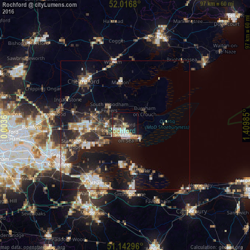
Analysis of Rochford night lights 2016
Square area 10x10 km:
 5.21%
5.21%90-99
10.03%80-89
8.16%70-79
7.89%60-69
2.54%50-59
2.14%40-49
2.41%30-39
5.08%20-29
15.64%10-19
21.79%0-9
19.12%Square area 50x50 km:
2.03%90-99
2.81%80-89
1.74%70-79
1.91%60-69
1.74%50-59
1.82%40-49
2.85%30-39
2.96%20-29
6.57%10-19
13.22%0-9
62.35%Clear (daylight) street map image can be seen on geolist.org.
Map coordinates:
52° 1' 0.5" North, 0° 0' 13" East
51° 34' 55.1" North, 0° 42' 24.2" East
51° 8' 34.7" North, 1° 24' 35.5" East
Some cities around Rochford sort by population:
• Southend-on-Sea
4.9 km =3 mi,  173°
173°
• South Benfleet
10.7 km =6.6 mi,  252°
252°
• Canvey Island
11 km =6.8 mi,  232°
232°
• Wickford
13.1 km =8.1 mi,  284°
284°
• Rayleigh
7.1 km =4.4 mi,  273°
273°
• Hadleigh
7.4 km =4.6 mi,  244°
244°
• Burnham-on-Crouch
9.4 km =5.8 mi,  52°
52°
• Great Wakering
7.5 km =4.7 mi,  116°
116°
2639265 (p: 16,739)
Sources (retrieved 2019-11-25):
» Earth at Night: Flat Maps 2012, 2016