Padiham night lights from space
Night Light of Padiham (England) from space (United Kingdom) Src. Average luminocity for 10x10km area is 28.9921% and for 50x50km: 16.6343%.
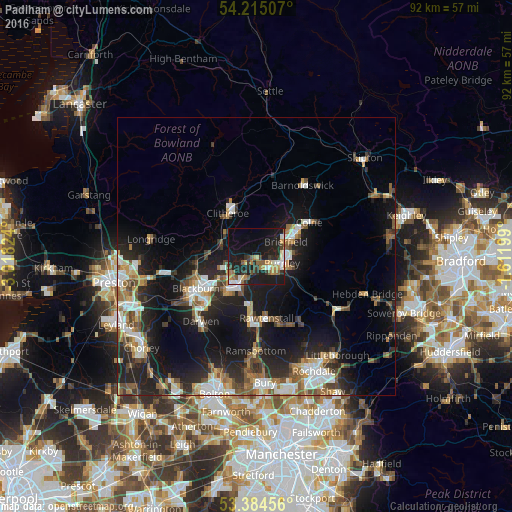
Analysis of Padiham night lights 2016
Square area 10x10 km:
 2.78%
2.78%90-99
3.17%80-89
2.12%70-79
5.42%60-69
4.76%50-59
4.23%40-49
1.85%30-39
6.61%20-29
8.6%10-19
37.96%0-9
22.49%Square area 50x50 km:
2.35%90-99
2.94%80-89
1.02%70-79
1.86%60-69
2.48%50-59
2.5%40-49
2.23%30-39
2.28%20-29
6.09%10-19
14.04%0-9
62.21%Clear (daylight) street map image can be seen on geolist.org.
Map coordinates:
54° 12' 54.3" North, 3° 1' 5.7" West
53° 48' 6.7" North, 2° 18' 54.4" West
53° 23' 4.4" North, 1° 36' 43.2" West
Some cities around Padiham sort by population:
• Burnley
5.4 km =3.4 mi,  92°
92°
• Accrington
6.1 km =3.8 mi,  208°
208°
• Nelson
8.3 km =5.2 mi,  65°
65°
• Great Harwood
6.4 km =4 mi,  253°
253°
• Brierfield
5.9 km =3.7 mi,  64°
64°
• Clayton le Moors
6 km =3.7 mi,  228°
228°
• Rishton
7.5 km =4.7 mi,  240°
240°
• Barrowford
8.1 km =5 mi,  51°
51°
2640687 (p: 11,338)
Sources (retrieved 2019-11-25):
» Earth at Night: Flat Maps 2012, 2016