Accrington night lights from space
Night Light of Accrington (England) from space (United Kingdom) Src. Average luminocity for 10x10km area is 36.3472% and for 50x50km: 25.57%.
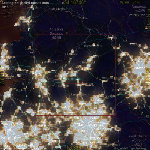

Analysis of Accrington night lights 2016
Square area 10x10 km:
 3.54%
3.54%90-99
5.18%80-89
1.52%70-79
5.3%60-69
6.06%50-59
6.19%40-49
5.68%30-39
6.57%20-29
16.29%10-19
43.69%0-9
0%Square area 50x50 km:
4.31%90-99
5.16%80-89
2.29%70-79
3.11%60-69
4.26%50-59
3.61%40-49
3.56%30-39
3.08%20-29
7.05%10-19
14.47%0-9
49.1%Clear (daylight) street map image can be seen on geolist.org.
Map coordinates:
54° 10' 2.9" North, 3° 3' 42.3" West
53° 45' 13.6" North, 2° 21' 31.1" West
53° 20' 9.6" North, 1° 39' 19.8" West
Some cities around Accrington sort by population:
• Blackburn
8.2 km =5.1 mi,  267°
267°
• Darwen
9.3 km =5.8 mi,  228°
228°
• Rawtenstall
7.7 km =4.8 mi,  140°
140°
• Haslingden
6.1 km =3.8 mi,  157°
157°
• Great Harwood
4.8 km =3 mi,  316°
316°
• Padiham
6.1 km =3.8 mi,  28°
28°
• Clayton le Moors
2.2 km =1.4 mi,  311°
311°
• Rishton
4 km =2.5 mi,  293°
293°
2657770 (p: 35,318)
Sources (retrieved 2019-11-25):
» Earth at Night: Flat Maps 2012, 2016