High Barnet night lights from space
Night Light of High Barnet (England) from space (United Kingdom) Src. Average luminocity for 10x10km area is 66.9692% and for 50x50km: 59.0457%.
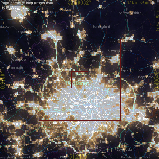
Analysis of High Barnet night lights 2016
Square area 10x10 km:
 11.62%
90-99
15.55%80-89
9.24%70-79
9.1%60-69
13.73%50-59
12.75%40-49
10.08%30-39
12.89%20-29
5.04%10-19
0%0-9
0%Square area 50x50 km:
25%90-99
14%80-89
4.8%70-79
3.33%60-69
4.52%50-59
4.93%40-49
4.93%30-39
6.14%20-29
7.78%10-19
11.09%0-9
13.48%Clear (daylight) street map image can be seen on geolist.org.
Map coordinates:
52° 5' 25.2" North, 0° 54' 38.9" West
51° 39' 22.4" North, 0° 12' 27.6" West
51° 13' 4.4" North, 0° 29' 43.6" East
Some cities around High Barnet sort by population:
• Enfield Town
8.5 km =5.3 mi,  93°
93°
• Borehamwood
4.8 km =3 mi,  267°
267°
• Barnet
0.9 km =0.6 mi,  142°
142°
• Potters Bar
4.6 km =2.9 mi,  25°
25°
• Hadley Wood
2.9 km =1.8 mi,  65°
65°
• Crouch End
10.3 km =6.4 mi,  145°
145°
• Edgware
6.7 km =4.2 mi,  224°
224°
• Radlett
8.3 km =5.2 mi,  293°
293°
6941037 (p: 7,062)
Sources (retrieved 2019-11-25):
» Earth at Night: Flat Maps 2012, 2016