East Leake night lights from space
Night Light of East Leake (England) from space (United Kingdom) Src. Average luminocity for 10x10km area is 17.1755% and for 50x50km: 26.4914%.
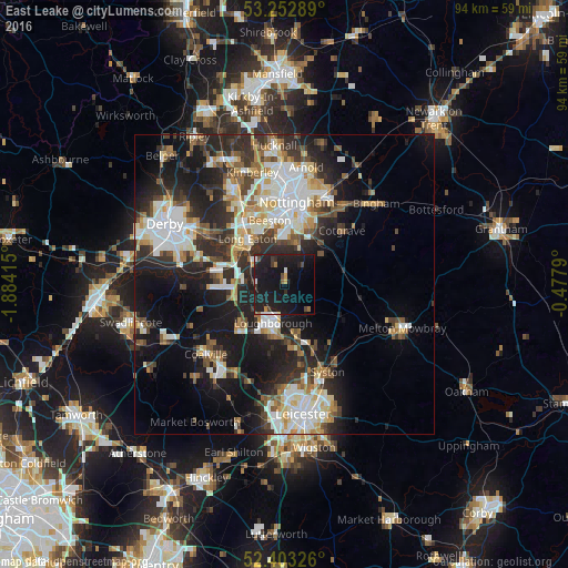
Analysis of East Leake night lights 2016
Square area 10x10 km:
 1.39%
1.39%90-99
1.39%80-89
0.25%70-79
1.01%60-69
1.52%50-59
1.01%40-49
2.02%30-39
2.65%20-29
7.58%10-19
47.85%0-9
33.33%Square area 50x50 km:
5.1%90-99
5.64%80-89
2.85%70-79
2.36%60-69
3.04%50-59
3.15%40-49
3.21%30-39
4.02%20-29
8.64%10-19
16.02%0-9
45.97%Clear (daylight) street map image can be seen on geolist.org.
Map coordinates:
53° 15' 10.4" North, 1° 53' 2.9" West
52° 49' 48.5" North, 1° 10' 51.7" West
52° 24' 11.7" North, 0° 28' 40.4" West
Some cities around East Leake sort by population:
• Loughborough
7.2 km =4.5 mi,  190°
190°
• Long Eaton
9.7 km =6 mi,  321°
321°
• Shepshed
10.3 km =6.4 mi,  225°
225°
• Keyworth
7.6 km =4.7 mi,  53°
53°
• Castle Donington
10.9 km =6.8 mi,  277°
277°
• Ruddington
7.3 km =4.5 mi,  16°
16°
• Barrow upon Soar
9 km =5.6 mi,  164°
164°
• Quorndon
9.5 km =5.9 mi,  176°
176°
2650397 (p: 6,337)
Sources (retrieved 2019-11-25):
» Earth at Night: Flat Maps 2012, 2016