Darfield night lights from space
Night Light of Darfield (England) from space (United Kingdom) Src. Average luminocity for 10x10km area is 52.8426% and for 50x50km: 36.1309%.
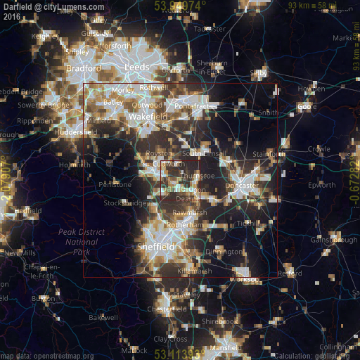
Analysis of Darfield night lights 2016
Square area 10x10 km:
 7.94%
7.94%90-99
8.2%80-89
7.14%70-79
8.86%60-69
7.8%50-59
4.5%40-49
8.47%30-39
17.86%20-29
28.57%10-19
0.66%0-9
0%Square area 50x50 km:
7.29%90-99
7.8%80-89
3.58%70-79
4.21%60-69
4%50-59
4.41%40-49
4.58%30-39
6.99%20-29
11.72%10-19
13.8%0-9
31.63%Clear (daylight) street map image can be seen on geolist.org.
Map coordinates:
53° 56' 59.1" North, 2° 4' 44.7" West
53° 32' 2" North, 1° 22' 33.4" West
53° 6' 50.1" North, 0° 40' 22.2" West
Some cities around Darfield sort by population:
• Barnsley
7.3 km =4.5 mi,  284°
284°
• Rawmarsh
8.4 km =5.2 mi,  165°
165°
• Wath upon Dearne
4 km =2.5 mi,  149°
149°
• Hoyland Nether
6.2 km =3.9 mi,  232°
232°
• Wombwell
1.9 km =1.2 mi, 226°
• Mexborough
7.1 km =4.4 mi,  128°
128°
• Bolton upon Dearne
4.4 km =2.7 mi,  116°
116°
• Cudworth
4.9 km =3 mi,  327°
327°
2651520 (p: 8,246)
Sources (retrieved 2019-11-25):
» Earth at Night: Flat Maps 2012, 2016