Bolton upon Dearne night lights from space
Night Light of Bolton upon Dearne (England) from space (United Kingdom) Src. Average luminocity for 10x10km area is 47.0476% and for 50x50km: 34.4858%.
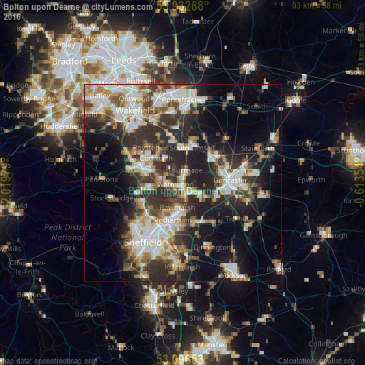
Analysis of Bolton upon Dearne night lights 2016
Square area 10x10 km:
 6.35%
6.35%90-99
6.08%80-89
7.67%70-79
7.14%60-69
4.89%50-59
2.91%40-49
10.45%30-39
14.42%20-29
24.87%10-19
15.21%0-9
0%Square area 50x50 km:
6.88%90-99
7.11%80-89
3.36%70-79
4.01%60-69
3.64%50-59
4.37%40-49
4.31%30-39
6.68%20-29
11.74%10-19
14.28%0-9
33.61%Clear (daylight) street map image can be seen on geolist.org.
Map coordinates:
53° 55' 57.6" North, 2° 1' 11.2" West
53° 31' 0" North, 1° 19' 0" West
53° 5' 47.5" North, 0° 36' 48.7" West
Some cities around Bolton upon Dearne sort by population:
• Rawmarsh
6.5 km =4 mi,  196°
196°
• Wath upon Dearne
2.5 km =1.6 mi,  231°
231°
• Conisbrough
6.8 km =4.2 mi,  124°
124°
• Hoyland Nether
9 km =5.6 mi,  258°
258°
• Wombwell
5.3 km =3.3 mi,  276°
276°
• Mexborough
3 km =1.9 mi,  147°
147°
• Cudworth
8.9 km =5.5 mi,  312°
312°
• Darfield
4.4 km =2.7 mi,  296°
296°
2655230 (p: 13,236)
Sources (retrieved 2019-11-25):
» Earth at Night: Flat Maps 2012, 2016