Crumlin night lights from space
Night Light of Crumlin (Wales) from space (United Kingdom) Src. Average luminocity for 10x10km area is 23.4006% and for 50x50km: 17.4297%.
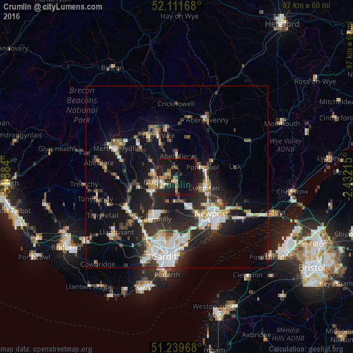
Analysis of Crumlin night lights 2016
Square area 10x10 km:
 1.26%
1.26%90-99
1.82%80-89
2.1%70-79
5.04%60-69
3.22%50-59
4.76%40-49
1.68%30-39
1.4%20-29
8.54%10-19
35.99%0-9
34.17%Square area 50x50 km:
2.76%90-99
3.48%80-89
1.31%70-79
1.87%60-69
1.72%50-59
1.89%40-49
2.24%30-39
2.87%20-29
6.14%10-19
13.69%0-9
62.03%Clear (daylight) street map image can be seen on geolist.org.
Map coordinates:
52° 6' 42" North, 3° 50' 18.2" West
51° 40' 40" North, 3° 8' 7" West
51° 14' 22.8" North, 2° 25' 55.7" West
Some cities around Crumlin sort by population:
• Pontypool
6.8 km =4.2 mi,  67°
67°
• Risca
8.1 km =5 mi,  162°
162°
• Blackwood
5.1 km =3.2 mi,  257°
257°
• Bargoed
6.8 km =4.2 mi,  275°
275°
• Abertillery
5.8 km =3.6 mi,  0°
0°
• Abercarn
3.4 km =2.1 mi,  179°
179°
• Newbridge
1.2 km =0.7 mi,  173°
173°
• Hengoed
7.3 km =4.5 mi,  245°
245°
2651805 (p: 5,947)
Sources (retrieved 2019-11-25):
» Earth at Night: Flat Maps 2012, 2016