Blackwood night lights from space
Night Light of Blackwood (Wales) from space (United Kingdom) Src. Average luminocity for 10x10km area is 37.098% and for 50x50km: 18.249%.
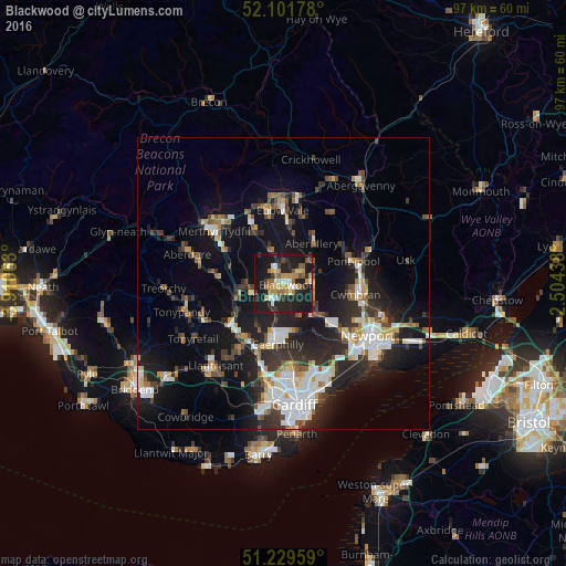
Analysis of Blackwood night lights 2016
Square area 10x10 km:
 2.52%
2.52%90-99
4.9%80-89
5.18%70-79
6.86%60-69
7.28%50-59
5.74%40-49
2.66%30-39
2.94%20-29
17.37%10-19
42.3%0-9
2.24%Square area 50x50 km:
2.96%90-99
3.59%80-89
1.37%70-79
1.85%60-69
1.78%50-59
1.97%40-49
2.33%30-39
3.1%20-29
6.58%10-19
15.1%0-9
59.36%Clear (daylight) street map image can be seen on geolist.org.
Map coordinates:
52° 6' 6.4" North, 3° 54' 38.3" West
51° 40' 4" North, 3° 12' 27" West
51° 13' 46.5" North, 2° 30' 15.8" West
Some cities around Blackwood sort by population:
• Gelligaer
3.4 km =2.1 mi,  263°
263°
• Bargoed
2.5 km =1.6 mi,  314°
314°
• Nelson
5.5 km =3.4 mi,  253°
253°
• Treharris
6.9 km =4.3 mi,  267°
267°
• Abercarn
5.5 km =3.4 mi,  114°
114°
• Newbridge
5.1 km =3.2 mi,  91°
91°
• Crumlin
5.1 km =3.2 mi,  77°
77°
• Hengoed
2.5 km =1.6 mi,  221°
221°
3345317 (p: 15,476)
Sources (retrieved 2019-11-25):
» Earth at Night: Flat Maps 2012, 2016