Abertillery night lights from space
Night Light of Abertillery (Wales) from space (United Kingdom) Src. Average luminocity for 10x10km area is 13.4678% and for 50x50km: 14.9758%.
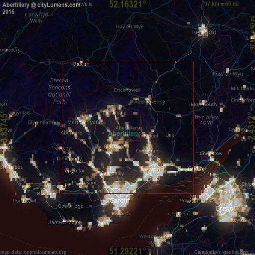
Analysis of Abertillery night lights 2016
Square area 10x10 km:
 0.14%
0.14%90-99
0.56%80-89
1.54%70-79
0.28%60-69
0.98%50-59
3.78%40-49
2.1%30-39
2.66%20-29
4.76%10-19
24.51%0-9
58.68%Square area 50x50 km:
1.95%90-99
2.57%80-89
1.26%70-79
1.77%60-69
1.65%50-59
1.79%40-49
2.04%30-39
2.57%20-29
5.7%10-19
12.91%0-9
65.79%Clear (daylight) street map image can be seen on geolist.org.
Map coordinates:
52° 9' 47.6" North, 3° 50' 14.8" West
51° 43' 47.3" North, 3° 8' 3.6" West
51° 17' 32" North, 2° 25' 52.3" West
Some cities around Abertillery sort by population:
• Pontypool
7 km =4.3 mi,  117°
117°
• Ebbw Vale
7.3 km =4.5 mi,  316°
316°
• Blackwood
8.5 km =5.3 mi,  216°
216°
• Brynmawr
8.5 km =5.3 mi,  336°
336°
• Victoria
5 km =3.1 mi,  296°
296°
• Newbridge
7 km =4.3 mi,  179°
179°
• Crumlin
5.8 km =3.6 mi, 180°
• Blaenavon
6 km =3.7 mi,  34°
34°
2657784 (p: 10,946)
Sources (retrieved 2019-11-25):
» Earth at Night: Flat Maps 2012, 2016