Countesthorpe night lights from space
Night Light of Countesthorpe (England) from space (United Kingdom) Src. Average luminocity for 10x10km area is 30.2778% and for 50x50km: 18.2254%.
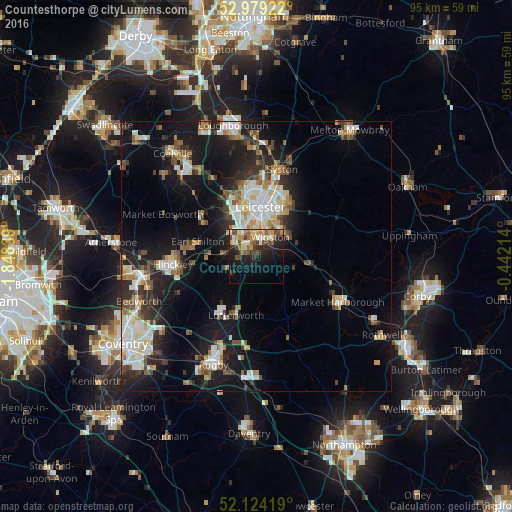
Analysis of Countesthorpe night lights 2016
Square area 10x10 km:
 2.25%
2.25%90-99
3.84%80-89
3.7%70-79
4.89%60-69
5.16%50-59
4.89%40-49
7.28%30-39
3.84%20-29
10.05%10-19
22.49%0-9
31.61%Square area 50x50 km:
2.96%90-99
3.64%80-89
1.97%70-79
1.47%60-69
2.23%50-59
2.37%40-49
2.26%30-39
2.34%20-29
4.84%10-19
14.49%0-9
61.42%Clear (daylight) street map image can be seen on geolist.org.
Map coordinates:
52° 58' 45.2" North, 1° 50' 54.2" West
52° 33' 13.6" North, 1° 8' 42.9" West
52° 7' 27.1" North, 0° 26' 31.7" West
Some cities around Countesthorpe sort by population:
• Leicester
9.5 km =5.9 mi,  5°
5°
• Wigston Magna
4.7 km =2.9 mi,  49°
49°
• Oadby
7.2 km =4.5 mi,  35°
35°
• Broughton Astley
5.7 km =3.5 mi,  239°
239°
• Enderby
5.6 km =3.5 mi,  312°
312°
• Narborough
4 km =2.5 mi,  291°
291°
• Blaby
2.8 km =1.7 mi,  332°
332°
• Kibworth Harcourt
10.2 km =6.3 mi,  95°
95°
2652239 (p: 6,377)
Sources (retrieved 2019-11-25):
» Earth at Night: Flat Maps 2012, 2016