Narborough night lights from space
Night Light of Narborough (England) from space (United Kingdom) Src. Average luminocity for 10x10km area is 35.0106% and for 50x50km: 20.429%.
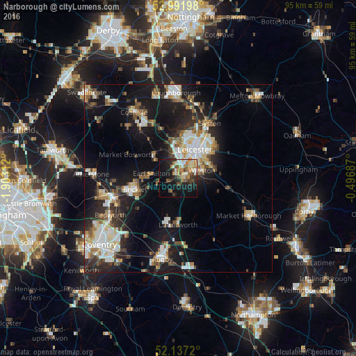
Analysis of Narborough night lights 2016
Square area 10x10 km:
 3.31%
3.31%90-99
6.35%80-89
4.76%70-79
4.76%60-69
6.61%50-59
4.5%40-49
5.95%30-39
3.97%20-29
9.52%10-19
25.53%0-9
24.74%Square area 50x50 km:
3.39%90-99
4.1%80-89
2.22%70-79
1.75%60-69
2.56%50-59
2.66%40-49
2.44%30-39
2.65%20-29
5.65%10-19
15.63%0-9
56.96%Clear (daylight) street map image can be seen on geolist.org.
Map coordinates:
52° 59' 31.1" North, 1° 54' 11.2" West
52° 34' 0" North, 1° 12' 0" West
52° 8' 13.9" North, 0° 29' 48.7" West
Some cities around Narborough sort by population:
• Wigston Magna
7.4 km =4.6 mi,  77°
77°
• Earl Shilton
7.9 km =4.9 mi,  278°
278°
• Glenfield
8.9 km =5.5 mi,  2°
2°
• Kirby Muxloe
7.3 km =4.5 mi,  345°
345°
• Broughton Astley
4.5 km =2.8 mi,  195°
195°
• Enderby
2.4 km =1.5 mi, 349°
• Countesthorpe
4 km =2.5 mi,  111°
111°
• Blaby
2.6 km =1.6 mi,  67°
67°
2641884 (p: 6,321)
Sources (retrieved 2019-11-25):
» Earth at Night: Flat Maps 2012, 2016