Wigston Magna night lights from space
Night Light of Wigston Magna (England) from space (United Kingdom) Src. Average luminocity for 10x10km area is 38.6997% and for 50x50km: 16.4328%.
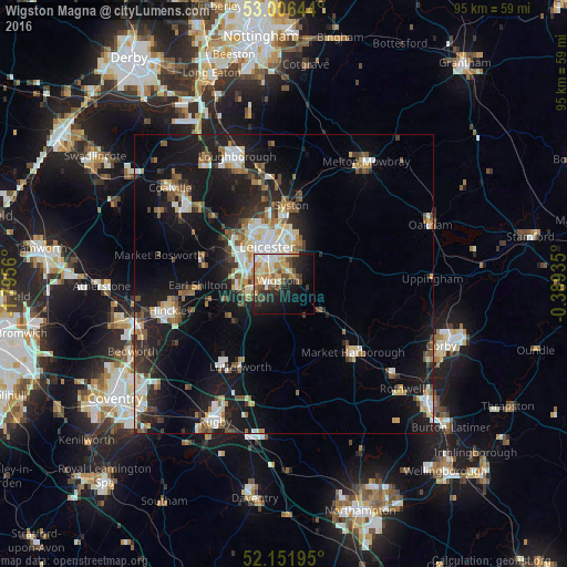

Analysis of Wigston Magna night lights 2016
Square area 10x10 km:
 3.57%
3.57%90-99
8.2%80-89
5.82%70-79
9.52%60-69
3.7%50-59
3.17%40-49
7.94%30-39
3.57%20-29
10.19%10-19
20.37%0-9
23.94%Square area 50x50 km:
2.35%90-99
2.92%80-89
1.72%70-79
1.46%60-69
2.12%50-59
2.27%40-49
2.15%30-39
2.12%20-29
4.31%10-19
15.01%0-9
63.58%Clear (daylight) street map image can be seen on geolist.org.
Map coordinates:
53° 0' 23.2" North, 1° 47' 44.2" West
52° 34' 52.6" North, 1° 5' 32.9" West
52° 9' 7" North, 0° 23' 21.7" West
Some cities around Wigston Magna sort by population:
• Leicester
6.9 km =4.3 mi,  337°
337°
• Oadby
2.8 km =1.7 mi,  12°
12°
• Glenfield
10 km =6.2 mi,  316°
316°
• Enderby
7.7 km =4.8 mi,  275°
275°
• Countesthorpe
4.7 km =2.9 mi,  229°
229°
• Narborough
7.4 km =4.6 mi,  257°
257°
• Blaby
4.9 km =3 mi, 262°
• Kibworth Harcourt
7.8 km =4.8 mi,  121°
121°
2633936 (p: 33,720)
Sources (retrieved 2019-11-25):
» Earth at Night: Flat Maps 2012, 2016