Broughton Astley night lights from space
Night Light of Broughton Astley (England) from space (United Kingdom) Src. Average luminocity for 10x10km area is 12.8056% and for 50x50km: 19.3656%.
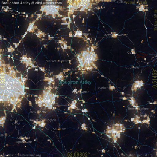
Analysis of Broughton Astley night lights 2016
Square area 10x10 km:
 0%
0%90-99
0%80-89
1.06%70-79
0.53%60-69
2.25%50-59
2.78%40-49
3.17%30-39
3.31%20-29
4.5%10-19
15.74%0-9
66.67%Square area 50x50 km:
3.03%90-99
3.84%80-89
1.98%70-79
1.67%60-69
2.29%50-59
2.45%40-49
2.3%30-39
2.65%20-29
5.77%10-19
15.83%0-9
58.16%Clear (daylight) street map image can be seen on geolist.org.
Map coordinates:
52° 57' 12.8" North, 1° 55' 14.9" West
52° 31' 40.3" North, 1° 13' 3.6" West
52° 5' 52.9" North, 0° 30' 52.4" West
Some cities around Broughton Astley sort by population:
• Hinckley
10.8 km =6.7 mi,  276°
276°
• Wigston Magna
10.3 km =6.4 mi,  54°
54°
• Earl Shilton
8.6 km =5.3 mi,  309°
309°
• Lutterworth
8 km =5 mi,  172°
172°
• Enderby
6.7 km =4.2 mi,  6°
6°
• Countesthorpe
5.7 km =3.5 mi,  59°
59°
• Narborough
4.5 km =2.8 mi,  15°
15°
• Blaby
6.4 km =4 mi,  34°
34°
2654502 (p: 8,940)
Sources (retrieved 2019-11-25):
» Earth at Night: Flat Maps 2012, 2016