Cookstown night lights from space
Night Light of Cookstown (Northern Ireland) from space (United Kingdom) Src. Average luminocity for 10x10km area is 7.604% and for 50x50km: 2.3557%.
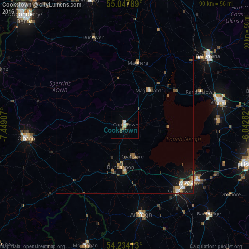
Analysis of Cookstown night lights 2016
Square area 10x10 km:
 1.38%
1.38%90-99
1.13%80-89
0.5%70-79
1.13%60-69
0.88%50-59
0.5%40-49
1.88%30-39
1.13%20-29
0%10-19
0.5%0-9
90.98%Square area 50x50 km:
0.24%90-99
0.28%80-89
0.2%70-79
0.32%60-69
0.47%50-59
0.45%40-49
0.39%30-39
0.25%20-29
0.38%10-19
1.25%0-9
95.76%Clear (daylight) street map image can be seen on geolist.org.
Map coordinates:
55° 2' 52.4" North, 7° 26' 56.7" West
54° 38' 35" North, 6° 44' 45.4" West
54° 14' 2.9" North, 6° 2' 34.2" West
Some cities around Cookstown sort by population:
• Craigavon
31.8 km =19.8 mi,  133°
133°
• Portadown
31.3 km =19.4 mi,  141°
141°
• Armagh
33 km =20.5 mi,  171°
171°
• Dungannon
15.6 km =9.7 mi,  185°
185°
• Magherafelt
15.2 km =9.4 mi,  36°
36°
• Coalisland
11.6 km =7.2 mi, 165°
• Randalstown
31 km =19.3 mi,  67°
67°
• Crumlin
34.3 km =21.3 mi,  94°
94°
2652417 (p: 11,081)
Sources (retrieved 2019-11-25):
» Earth at Night: Flat Maps 2012, 2016