Crumlin night lights from space
Night Light of Crumlin (Northern Ireland) from space (United Kingdom) Src. Average luminocity for 10x10km area is 5.0777% and for 50x50km: 12.4856%.
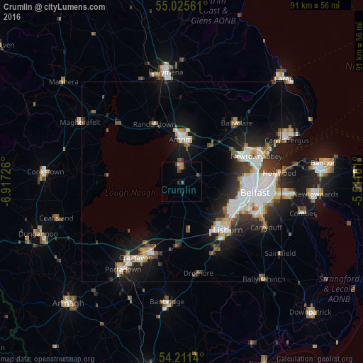
Analysis of Crumlin night lights 2016
Square area 10x10 km:
 0.25%
0.25%90-99
0.25%80-89
0%70-79
1.5%60-69
1%50-59
1%40-49
0.75%30-39
1.25%20-29
1.13%10-19
1.63%0-9
91.23%Square area 50x50 km:
2.86%90-99
2.69%80-89
0.88%70-79
1.19%60-69
1.2%50-59
1.32%40-49
1.24%30-39
1.9%20-29
3.19%10-19
7.68%0-9
75.84%Clear (daylight) street map image can be seen on geolist.org.
Map coordinates:
55° 1' 32.2" North, 6° 55' 2.1" West
54° 37' 13.9" North, 6° 12' 50.9" West
54° 12' 41" North, 5° 30' 39.6" West
Some cities around Crumlin sort by population:
• Belfast
18.8 km =11.7 mi,  98°
98°
• Lisburn
15.8 km =9.8 mi,  133°
133°
• Newtownabbey
20.1 km =12.5 mi,  77°
77°
• Castlereagh
21.9 km =13.6 mi, 103°
• Antrim
8.9 km =5.5 mi,  5°
5°
• Ballyclare
20 km =12.4 mi,  43°
43°
• Jordanstown
21.4 km =13.3 mi,  70°
70°
• Randalstown
15.4 km =9.6 mi,  339°
339°
2651804 (p: 5,149)
Sources (retrieved 2019-11-25):
» Earth at Night: Flat Maps 2012, 2016