Coalisland night lights from space
Night Light of Coalisland (Northern Ireland) from space (United Kingdom) Src. Average luminocity for 10x10km area is 7.5395% and for 50x50km: 3.4167%.
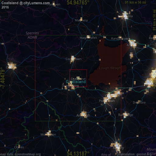
Analysis of Coalisland night lights 2016
Square area 10x10 km:
 0.12%
0.12%90-99
0.12%80-89
0.72%70-79
1.32%60-69
2.27%50-59
2.39%40-49
1.2%30-39
0.48%20-29
1.44%10-19
2.39%0-9
87.56%Square area 50x50 km:
0.32%90-99
0.41%80-89
0.3%70-79
0.46%60-69
0.58%50-59
0.6%40-49
0.58%30-39
0.4%20-29
0.53%10-19
2.31%0-9
93.5%Clear (daylight) street map image can be seen on geolist.org.
Map coordinates:
54° 56' 51.5" North, 7° 24' 17.2" West
54° 32' 30.5" North, 6° 42' 6" West
54° 7' 54.7" North, 5° 59' 54.7" West
Some cities around Coalisland sort by population:
• Craigavon
22.9 km =14.2 mi,  117°
117°
• Portadown
21.2 km =13.2 mi,  128°
128°
• Banbridge
34.4 km =21.4 mi, 128°
• Armagh
21.4 km =13.3 mi,  173°
173°
• Dungannon
6 km =3.7 mi,  224°
224°
• Cookstown
11.6 km =7.2 mi,  345°
345°
• Magherafelt
24.3 km =15.1 mi,  14°
14°
• Crumlin
32.6 km =20.3 mi,  74°
74°
2652703 (p: 5,416)
Sources (retrieved 2019-11-25):
» Earth at Night: Flat Maps 2012, 2016