Adlington night lights from space
Night Light of Adlington (England) from space (United Kingdom) Src. Average luminocity for 10x10km area is 32.8573% and for 50x50km: 44.6117%.
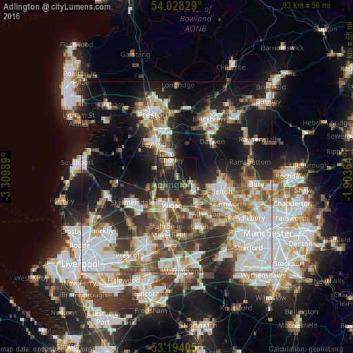
Analysis of Adlington night lights 2016
Square area 10x10 km:
 2.27%
2.27%90-99
4.42%80-89
2.78%70-79
1.64%60-69
4.04%50-59
6.19%40-49
8.08%30-39
7.07%20-29
29.17%10-19
24.12%0-9
10.23%Square area 50x50 km:
11.04%90-99
9.42%80-89
3.97%70-79
4.78%60-69
5.87%50-59
5.21%40-49
6.07%30-39
6.39%20-29
10.77%10-19
17.63%0-9
18.83%Clear (daylight) street map image can be seen on geolist.org.
Map coordinates:
54° 1' 41.8" North, 3° 18' 35.6" West
53° 36' 47.6" North, 2° 36' 24.3" West
53° 11' 38.6" North, 1° 54' 13.1" West
Some cities around Adlington sort by population:
• Wigan
8.1 km =5 mi,  194°
194°
• Chorley
4.1 km =2.5 mi,  350°
350°
• Horwich
4 km =2.5 mi,  109°
109°
• Coppull
3.7 km =2.3 mi,  291°
291°
• Euxton
7.8 km =4.8 mi,  324°
324°
• Appley Bridge
8.5 km =5.3 mi,  242°
242°
• Shevington
7.3 km =4.5 mi,  231°
231°
• Blackrod
2.9 km =1.8 mi,  143°
143°
2657668 (p: 7,965)
Sources (retrieved 2019-11-25):
» Earth at Night: Flat Maps 2012, 2016